Why I love the Carretera Austral
For me, the Carretera Austral is the pinnacle of why Patagonia keeps its travelers in indescribable awe. It surpasses the allure of Torres del Paine National Park in the south and is packed with enough pristine glaciers and lakes to give the Perito Moreno Glacier and Los Glaciares National Park in Argentina a run for their money.
The Queulat Glacier (Queulat Hanging Glacier) The Queulat National Park near Puyuhuapi along the Carretera Austral
The Hanging Snowdrift in Queulat National Park. No, he had never seen anything like it.
What you can expect to discover here are endless opportunities for camping and trekking, appreciating nature in its most remote and intact state, and being lucky enough to experience the most incredible road trip in Patagonia, and perhaps South America.
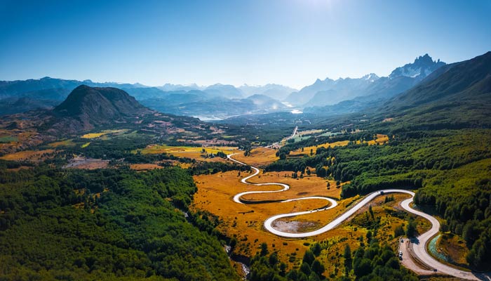
What is the Carretera Austral?

The Carretera Austral is in Chilean Patagonia.
There are 1,240 kilometers of winding road that crosses the northern section of Chilean Patagonia.
Also known as Ruta 7 or "Austral Route", this highway connects its northernmost point, Puerto Montt (in Chile's Lake District), and its southernmost point, Villa O'Higgins (in the Aysén region).
It encompasses a territory that is always bordering Argentina by the Andes Mountains and bordering on the west with the narrow channels and fjords of the Pacific Ocean.
What makes it so captivating to visit is the fact that the Carretera Austral remains the only highway connecting Puerto Montt and the deep and remote regions of Northern Chilean Patagonia.
This region is one of the least inhabited in Chile, with an average of less than one person per square kilometer living here.
The state of the "Carretera Austral": Carretera Austral is still a work in progress, with large sections of the road still unpaved.
Map of the Carretera Austral
Why is it so famous?
It is partly due to its poor condition that the Carretera Austral has reached such a high status in the imagination of travelers.
Unpaved, with holes and shafts in the most complex areas: these are all qualities that have helped to secure the Carretera Austral as one of the most remote - and therefore most seductive - destinations.
Another feature of the highway's infamy is the fact that it was one of the main infrastructural legacies of the Pinochet dictatorship (which also killed and "disappeared" more than 40,000 people).
Before the 1980s, this part of Patagonia was practically disconnected from outside civilization, with no roads connecting most of the settlements that were beginning to grow.
The construction of the highway took twenty years and the locals still refer to it as "the Pinochet highway". You can even find a monument to the dictator in La Junta.
The Carretera Austral is also part of the brand new Route of the Parks, an initiative that stretches 2,735 kilometers from Puerto Montt to the very tip of Patagonia at Cape Horn and that aims to unite 17 Chilean national parks.
When is the best time to travel to the Carretera Austral?
One of the first things you should learn about Patagonia is how unpredictable the weather is. In Patagonia we always joke that there is no point in looking at the weather forecast, it is as if it were not exact.
You can have all 4 seasons in one day.
However, the best time to visit the Carretera Austral is between November and April. This period covers the end of spring, all of summer and the beginning of fall. This is when you can expect (but not guaranteed!) The driest and warmest weather (between 10˚C and 20˚C during January and February) and that all tourist facilities are open.
However, January and February are the months with the highest influx of visitors on the Carretera Austral and the hotels - and the mountains - can be full.
Also bear in mind that from May to October practically all hotels and tourism agencies and many restaurants are closed for the season, while the roads can become impassable due to rain and even snow and ice.
Where the Carretera Austral begins
While not officially along the Carretera Austral, Puerto Montt marks the northernmost end of the highway. As such, many travelers, whether they hope to explore the entire length or just part of it, begin their travels in Puerto Montt.
Puerto Montt

This port city itself is a bit rough around the edges and with little to appreciate beyond the views of Volcán Osorno and Volcán Calbuco (found to the northeast) experienced on a clear day.
The pretty wooden church of Puerto Montt
However, it is home to a number of ferry trips to Patagonia and beyond and is the main departure point for buses heading south.
If you have time to eat….
Chaitén and Pumalín National Park

Distance south of Puerto Montt: 240 kilometers
Distance north of Coyhaique: 421 kilometers
The largest city at the northern end of the Carretera Austral is Chaitén. A dusty place of five streets of ramshackle wooden houses nestled inside a wide bay, it is the gateway to one of the best national parks in Patagonia: Pumalín Douglas Tompkins.
One of two in the region that were established by the late Doug Tompkins, founder of the North Face adventure brand, Pumalín National Park (free) is exactly what you envisioned when you thought of hiking in Patagonia.
Here a multitude of picturesque campgrounds and trails have been established, the latter passing through the exuberant temperate Valdivian jungle to reach the fascinating lakes and waterfalls and the towering thousand-year-old larch trees.
My favorite hike is the one that leads to the crater of the Chaitén Volcano, a volcano that erupted in 2008 and devastated practically the entire town of Chaitén.
The Pumalín Douglas Tompkins National Park is a fantastic place to spend a few days, especially if you have your own camping equipment, although you can perfectly stay in Chaitén and enter and leave the park whenever you want.
Futaleufu

Distance south of Puerto Montt: 391 kilometers
Distance north of Coyhaique: 422 kilometers
Although not officially on the Carretera Austral, Futaleufú (aka Futa for locals) is a charming town worth a few days' detour.
Here you can spend hours walking trails with sublime views of mountains and lakes, participating in world-class rafting or kayaking, or simply enjoying the peaceful atmosphere of the laid-back city.
Expert-level rafting on the Futaleufú River draws Chilean crowds here during the summer, particularly as it is considered one of the best places in the world for this water sport. You can also organize kayaking on the tributaries of the Futa River.
The walking trails are also numerous. One of them is the route that goes up to Piedra La Aguila (Eagle Rock), where, through a series of rather steep but ultimately worthwhile changes, the path reaches the needle-like rock already some sensational views of the valley.
Puyuhuapi and Queulat National Park: hanging snowdrift

Distance south of Puerto Montt: 428 kilometers
Distance north of Coyhaique: 233 kilometers
One of the highlights of the Carretera Austral del norte is Puyuhuapi. This fjord town, normally shrouded in equal parts fog and wood smoke from the burners that heat locals' homes, feels very remote and Patagonian.
However, what you'll quickly notice here is the German architecture and language - a legacy of the German settlers who colonized the area in the 1930s.
The Hanging Glacier in Queulat National Park is among my favorite glaciers of all time.
Although it's a good distance from the glacier, the platform at the end of the 30-minute climb has great views. Observe the ice that breaks off the glacier and the two waterfalls fed by the glacier that drop 600 meters on the rocks below, before reaching the lagoon. It is simply spectacular.
Coyhaique

Distance south of Puerto Montt: 661 kilometers
The best place to stock up on food along the Carretera Austral (as most other towns and villages only offer the basics), Coyhaique is a charming but steamy town in Patagonia - regularly exceeding the pollution index. From Chile.
With free Wi-Fi in the main square, and delicious restaurants like Mama Gaucha and Casa Tropera (a microbrewery that also serves amazing burgers), it's easy to understand why I always end up spending more time than planned in this town.
Apart from the relative comfort of its facilities, there is not much else to do here. It is the main transportation hub, connecting destinations in the north and south and most will cross it after landing at the nearby Balmaceda Aerodrome or sailing to the port of Puerto Chacabuco, while it is an unavoidable stop if at least the half of the Carretera Austral.
Cerro Castillo National Park

Distance south of Puerto Montt: 757 kilometers
Distance south of Coyhaique: 98 kilometers
Situated between Puerto Río Tranquilo and Coyhaique, Villa Cerro Castillo is home to its namesake national park, Cerro Castillo.
Before visiting it, I had heard many raving about this park, ranking it among their favorite places in all of Patagonia.
The main attraction is Cerro Castillo, which thanks to its three mountain peaks has been compared to Torres del Paine in Southern Patagonia.
I will admit that this mountain is not that picturesque, but it is certainly a spectacular national park and - best of all - frequented by far fewer visitors when compared to Torres del Paine.
Always in Patagonia the density of people visiting local attractions conditions your perception of it.
Hiking here is also great for seeing huemules (the endangered deer of the southern Andes) and other native wildlife.
There are two main trails: The most popular is the steep 14-kilometer, six-hour, eight-hour hike that goes up the Cerro Castillo Mirador Trail to Cerro Castillo Lake (which is located below the summit). The trail is one kilometer northwest of town.
The second is the four / five-day, 51-kilometer hiking circuit known as the Cerro Castillo Crossing or the Las Horquetas Crossing. The latter is a challenging hike through a series of exposed mountain passes with panoramic views of glacier-filled peaks.
Puerto Río Tranquilo and the Marble Caverns

Distance south of Puerto Montt: 877 kilometers
Distance south of Coyhaique: 216 kilometers
There are few places like this in Patagonia: the incredible Marble Caves, whose swirls of blue, gray and black marble against the glacial blue of General Carrera Lake, you have to see.
Also, the trip along the shore of the lake to reach Puerto Río Tranquilo is truly fantastic.
Luckily, it is easy to visit. You can book a speedboat tour (1.5 hours) from the port of Puerto Río Tranquilo for only ($ 14 USD). Try to do the tour early in the morning to have the best lighting, although this is not as easy as you might think, as the departures depend on the weather conditions and the waves on the lake can be fierce.
General Carrera Lake is truly astonishing in beauty
Also visit the nearby Ventisquero San Rafael, 30 meters high, in the San Rafael National Park. A glacier retreating at an alarming rate, it is worth visiting to observe the ice that breaks off the glacier and into the sea, especially considering that scientists warn that it could disappear by 2030.
Chile Chico and Patagonia National park

Distance south of Puerto Montt: 814 kilometers
Distance south of Coyhaique: 154 kilometers
Located on the southeastern shore of Lake General Carrera, Chile Chico bathes in an unusually sunny and dry microclimate. Strangely, this part of the Carretera Austral grows cherries and is home to five endemic species of cacti - the last of which are considered the southernmost in the country.
But in addition to the city's favorable climate, Chile Chico is above all a point of transition for travelers leaving the Carretera Austral towards Argentina or for those coming in the opposite direction. Beyond this, it is the gateway to the hardly visited Jeinimeni Sector of the Patagonia National Park, about which little has been written.
For most visitors, Chile Chico is reached by a ferry that crosses the General Carrera Lake
Personally, I've never been, but I've heard there are some nice hikes through a privileged landscape of milky-colored lakes, glacial-colored mountain peaks, and rolling expanses of rough-edged Patagonian steppe.
Cochrane

Distance south of Puerto Montt: 991 kilometers
Distance south of Coyhaique: 330 kilometers
An hour's drive south of General Carrera Lake, Cochrane is Patagonia's next great adventure destination. It makes me think of what El Chaltén must have been like before the tourists arrived, with its laid-back atmosphere and wealth of adventure literally close at hand.
The best is undoubtedly the Patagonia National Park, the second of Doug Tompkins' great legacies to the Carretera Austral.
The two southern sectors of the park, Valle Chacabuco (free) and Tamango are home to varied ecosystems, from the arid steppe to the low mountains populated by southern beech forests. Beyond this truly fascinating landscape there are a host of excellent, well-marked hiking trails.
The landscape in the Patagonia National Park is spectacular
There are a handful of short day hikes, but you need a car to get here (you can hitchhike - I did - but it can take a long time) and also to drive between the trails, which stretch across a large area.
A much more accessible part of the national park is the Tamango Sector, which is located a few kilometers northeast of Cochrane. There are around ten trails here, ranging from an hour to ten and the most picturesque parts of the national park are those that border the pristine waters of Lake Cochrane, while the forests are inhabited by a small population of the critically endangered huemul of extinction. You can find a map of the trails in this section of the park here.
Caleta Tortel

Distance south of Puerto Montt: 1,116 kilometers
Distance south of Coyhaique: 455 kilometers
Nothing prepares you to see Caleta Tortel, officially the most extravagant city on the Carretera Austral. Clinging to the forested edges of a small hill and overlooking the blue waters of the Backer River, this settlement is unique in that it does not contain a single road.
The Plaza de Armas, on a promenade in Caleta Tortel, along the Carretera Austral
Even the Plaza de Armas (the main square) is on stilts
On the other hand, the wooden walkways allow access from one side to the other. It is truly magnificent in the sun, when the sun enhances the place and you can walk the trails practically floating on the water.
Beyond its picturesque appearance, the city also has access to a handful of glaciers, Ventisquero Steffens and Jorge Montt. You can visit it on a boat tour with one of the locals, keep in mind that tours only leave when there are eight passengers, so it can be difficult to organize one outside of January and February.
An aerial view of the wooden walkways in Caleta Tortel, along the Carretera Austral
Villa O'higgins

Distance south of Puerto Montt: 1,224 kilometers
Distance south of Coyhaique: 563 kilometers
When you arrive at Villa O'Higgins, you begin to appreciate how wild this corner of Patagonia is. There's a reason this small town didn't have road access until 1999 ... ... and it doesn't feel more accessible now that it does.
A sign that says "the end of the road" at the end of the Carretera Austral de la Patagonia near Villa O'Higgins
Surrounded by dramatic mountains on two sides and situated on a flat plain at the bottom of the valley, Villa O'Higgins still feels owned by the landscapes that man has invaded. It is also the official end of the Carretera Austral.
The biggest attraction here is the access to the Southern Patagonian Ice Field, which is located south of the city. The most accessible glacier in this mountain range is the O'Higgins glacier, whose cobalt ice face can be seen crashing against the sparkling waters of the lake of the same name from a sailboat.
My highlight when I was at Villa O'Higgins was an overflight of the O'Higgins glacier. Vicente Beasley from WINGS can take you over the glacier in his six-seater plane. It is an incredible flight, in which you can appreciate the height of the surrounding mountains (including Mount Fitz Roy across the border with Argentina, if you are lucky) and the depths of the cracks in the ice.
In fact, we have fallen just 20 meters above the glacier for an incredible approach experience. For an hour-long flight, expect to pay CLP $ 190,000 ($ 262 USD) per person and be aware that turbulence is common.
Crossing to Argentina through Paso Roballos and connection with Route 40
See Roballos crossing
If you have come here traveled the Carretera Austral, you may want to continue and cross into Argentina through the little-traveled Roballos border crossing and connect with Route 40 at the height of Bajo Caracoles.
Keep in mind that this crossing is very little traveled and you should check at the border before leaving to make sure it is open.
Another precaution to take is to leave early since you will have to drive a few kilometers to reach the next accommodation in Argentina.
I build your complete itinerary in a 60-minute video call. Without intermediaries.